Not sure this link will help, but it appears to be what you are asking for.
I just Googled "LIDAR Source Massachusetts" and this was the first link to pop up. Hope it's what you're looking for.
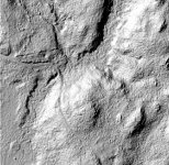
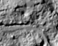
It is lidar but not of the quality you're getting in the other states. You have to download the tiles and open them in a reader. Once you have them open you'll see what I mean about quality.
Works for me..
This is just a quick example I picked from just outside Hatfield Mass... Typically I would research an area first to have a general idea of the history of an area and possibility of old cellar holes, roads, etc, and then use other technology to hone in on the exact location... However sometimes you come across something that isn't on the maps but definitely exists.