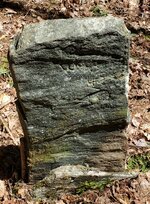
This marker represents the exact spot where three towns intersect
By 1829 Carleton’s maps were obsolete, due both to its intrinsic failings the original surveys and to the rapid pace of development in the State. So in 1829 and 1830 the legislature passed enabling legislation and commissioned
Simeon Borden to produce an entirely new state map. This was to be essentially a three-stage process: First, as in the 1790s each town was to survey its territory and submit a map to the State (Incidentally, nearly 100 of these towns were published, such as these maps of
Amherst, Hingham and
Leominster. Second, a statewide “geodetic” survey would be conducted, in which superb instruments and rigorous astronomical observations were used to establish a baseline from which could be developed a network of some 500 triangulated reference points across the state. Finally, the local data in the individual town maps would be reconciled and merged with the trigonometric survey to produce the state map. This was to be the first map of any state to be based on triangulation from geodetically-controlled points, though it reflected advanced map-making practices long in use in Europe.
After the Revolution Massachusetts was in dire need of an up-to-date state map. This was necessary for stimulating commerce and infrastructure development, delineating public lands available for sale, and allocating taxes. With a weak Federal government unable to provide support and itself short on cash, the State had to come up with creative models for funding these labor intensive projects.
In 1794 the legislature enacted a clever map-making project designed to shift the costs away from the State. Each town was required to conduct a survey at its own cost and submit a town plan to the Secretary of State. These were to be at a scale of 1 inch to 200 rods (1:39,600); indicate the length and bearing of town boundaries; delineate roads and waterways; and show the locations of meeting houses, schools, mills, mines &c. Under state auspices, the surveys would then be compiled and where necessary reconciled to produce maps of Massachusetts as well as Maine, which remained part of the state until 1820.
These surveys were conducted by the centuries-old
metes-and-boundsmethod. Using a compass for taking bearings and a rod (16.5 feet) or chain (66 feet) for measuring distances, surveyors worked their way in a continuous path along a town’s boundaries to be measured, recording bearings and distances between objects designated as boundary markers. The hundreds of resulting maps were of varying quality and ridden with inaccuracies, and only with much difficulty were they compiled by Boston mapmaker
Osgood Carleton into
An Accurate Map of the Commonwealth of Massachusetts and
Map of the District of Maine (1797). Though poorly engraved and difficult to read, these were an informational
tour de force, as they depict the state at a level of detail hitherto unimagined scale of 1:253,440 (Mass.) and 1:400,000 (Maine).