FINALLY found old map of my town after much research...need a bit of help though

marcus118

Forum Supporter
Joined
Jun 5, 2008
Messages
1,440
Location
Scotch Plains, NJ
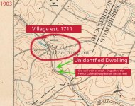
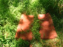
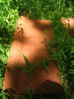
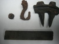
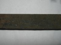
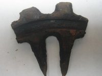
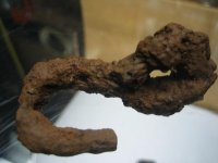
Hello all. I live near an old village that was est. in 1711 in central jersey. as a kid, i spent countless hours in the creek/woods near this village fishing, building forts, etc. One day i stumbled upon an old well about 10 yards away from the woods-line, near an old road leading up to this village. the well is halfway between the road and the creek and was always mysterious to me as there are no old houses in the immediate area. I decided to detect this area a few months ago and dug a Rev. War period french colonial navy button a few feet from the well. (ive posted this find in this forum in the past). i also dug an old horseshoes, oyster shells, nails, and odd metal pieces that i concluded to be wagon parts. a few members of this forum and others suggested there might have been some sort of dwelling near this well as part of the village down the road. perhaps a temporary, one room dwelling for those building a house down the road. after 2 months of looking through old maps of the area for a marking in this spot, i've finally found something very interesting. i cropped the map and made some markings of my own in photoshop for easier understanding. a few questions of the top of my head based on this illustration are:

1. would a cartographer in 1903 make a marking as pointed out in this picture for anything other than a house or building? i.e, shed, barn, etc.
2. the marking here is on the east side of the creek (much lower than the west side where the well is). Would it make sense to build on the low side of a creek for fear of flooding?
3. why would a house and the house's well be on opposite sides of a creek? especially with the well on high side.

I dont believe that this would have been a temporary house for the village down the road because it is depicted on a map in 1903. By then the villagers would have torn down this temporary dwelling and used the materials for the new house. I am extremely familiar with this wooded area in question, and have never come across any cellar holes. if you notice there is another small dot across from the one in question here that is also not in existence today.

any help, answers to my questions, or thoughts would be much appreciated. thanks for reading!
 

Attachments

  • creek.jpg
    creek.jpg
    94.8 KB · Views: 252
You have to remember this was 100 years ago and the high side of the creek may not have been that high. Maps like the one you are looking at point out a living dwelling. So at one time there was a dwelling there. Most houses in those days did not have cellars. My house in CT after research was built in 1897, celler added 1930's, we susspect for hiding liquer. Alot of towns have "insurance maps." These bmaps which usually have books that accompany them give very detailed measure ments of buildings and distances of property lines. These doubled as tax rolls for the town. Some times these rolls do not exist anymore but sometimes you get real lucky. Alot of insurance companies donated these rolls to the towns for historic reasons.

When I search old sites I look for 1 or two trees that do not belong. Much larger in diamater then the others. Houses were generally built near them to offer shade. Good luck on your hunt!
 
do you think i would be able to find information about this dwelling in old newspapers? perhaps i should take a trip to the county library. would they have documented news of the house being burnt down, flooded, decayed/torn down, etc do you think? near the site on the map, opposite the well, i found a bunch of these heavy stone things buried a few inches under. no idea what they are but the detector goes crazy over them so there must be metal inside the stone. extremely heavy and about 3 foot by 1 foot
 

Attachments

  • 2.jpg
    2.jpg
    119.4 KB · Views: 238
  • 3.jpg
    3.jpg
    77 KB · Views: 243
Hello, I have similar maps for my area and almost any structure is usually marked. I would bet the dot along the creek is a barn. If the stream has enough elevation change and a diversion channel it could be a mill but they usually have a lot of stone foundation left behind. I have noticed a lot of old barns within 50 feet of a stream I presume for ease of getting water for the animals.

As far as the well I have found a lot of unusual locations. Of interesting note, two times they were on the opposite side of the road from the old home site? I have a guess why, maybe a historian could confirm if it was so someone traveling the road that needed water didn't have to bother the resident to get some water whenever they passed by ?

Old maps try here: http://www.historicmapworks.com
 
usually those were mills (grist,saw,ect.)that were dotted on creeks or small rivers like that on those types of maps Marcus
 
Every dot on my map represents a house. Ill bet there was a house there. Put your detector in all metal and start searching around. When you start finding a lot of small iron you should be where the house was. Look for the square nails! Your in the right spot just keep looking.
 
thanks for all your input! i went back down to the well to hunt for the dot on the map, and sure enough it was there!!!!! the only thing is that it was on the opposite side of the creek that the map said it would be and directly in front of the well (so basically the house was on the high side of the creek, in between in the road and the well. before i discovered it, i was detecting all around the well until i literally tripped on a pile of rocks. after a few minutes of pulling away thick weeds, i knew if was the foundation. the house must have been very small because the foundation perimeter was not large. it is made entirely of rock, not cinder block (does this mean that it dates older than early 1900's?) I was only able to detect for a half hour or so before a storm hit, so i did not find much. i attached a few pics of what i found below that i have no idea what they are. one item appears to be a ruler because of the markings that really cant be seen from this pic. its rather heavy and appears to be copper or bronze. it looks as though it is broken in half at the 6 inch mark. one picture not listed here are some sort of metal pipes that i dug under one of the walls that may have lead to the well. hopefully i can make it back down there in the next few days.
 

Attachments

  • IMG_1550.jpg
    IMG_1550.jpg
    31.4 KB · Views: 179
  • IMG_1552.jpg
    IMG_1552.jpg
    31.6 KB · Views: 183
  • IMG_1553.jpg
    IMG_1553.jpg
    30.2 KB · Views: 183
  • IMG_1555.jpg
    IMG_1555.jpg
    35.9 KB · Views: 186
  • IMG_1556.jpg
    IMG_1556.jpg
    32.7 KB · Views: 178
Back
Top Bottom