
Tom_in_CA
Elite Member
- Joined
- Dec 23, 2013
- Messages
- 20,781
Not sure about southern CA, or SF bay area, but for my part of CA (Monterey Bay), every beach I saw was "flattened", for the most part. Ie.: "overpowered". Where : Instead of mother nature picking a parallel and eroding downwards (slopes, cuts, or scallops), it just brought down dry fluffy sand from up high, and spread it over the inter-tidal zone.
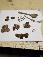
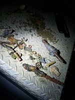
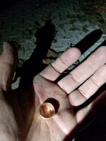
So far, I haven't seen where any "days after" effect has subsequently pulled that inter-tidal sand away (to fill in off-shore voids, as mother nature fixes her slopes after a big event). I did manage a few silver coins and a 14k ring on Thursday (the first day of the event). On Friday, I couldn't get away d/t work, and was only able to quickly reconn. a few beaches closer to my home. Carmel was still "flattened", as was Asilomar. But at least at Asilomar, there was 45-ish coins that tumbled out of the dunes. Inc. a merc & a few wheaties. But no gold. And the rest of the beach is not eroded or affected.
Yesterday / Saturday, was another bump on the swell, but it still didn't do anything that I could find. But admittedly I didn't scout reconn. much. Was just too disgusted. It even sanded back in the lone beach where we'd found ample targets on Thursday.
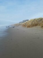
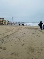
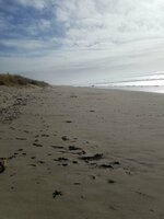
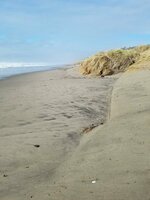
Here's some pix of Palm Beach in Watsonville on Thurs. late afternoon. And one Thursday low tide shot of the Santa Cruz Boardwalk. As you can see : Flattened. And to whatever extent it made a vertical angle on some of the dunes, that is pretty much the "normal" look there. And whatever sand came out, was merely spread on to the inter-tidal zone, as opposed to taken out in *true* erosion.
Did anyone from southern CA see any true & good erosion come out of this ?
So far, I haven't seen where any "days after" effect has subsequently pulled that inter-tidal sand away (to fill in off-shore voids, as mother nature fixes her slopes after a big event). I did manage a few silver coins and a 14k ring on Thursday (the first day of the event). On Friday, I couldn't get away d/t work, and was only able to quickly reconn. a few beaches closer to my home. Carmel was still "flattened", as was Asilomar. But at least at Asilomar, there was 45-ish coins that tumbled out of the dunes. Inc. a merc & a few wheaties. But no gold. And the rest of the beach is not eroded or affected.
Yesterday / Saturday, was another bump on the swell, but it still didn't do anything that I could find. But admittedly I didn't scout reconn. much. Was just too disgusted. It even sanded back in the lone beach where we'd found ample targets on Thursday.
Here's some pix of Palm Beach in Watsonville on Thurs. late afternoon. And one Thursday low tide shot of the Santa Cruz Boardwalk. As you can see : Flattened. And to whatever extent it made a vertical angle on some of the dunes, that is pretty much the "normal" look there. And whatever sand came out, was merely spread on to the inter-tidal zone, as opposed to taken out in *true* erosion.
Did anyone from southern CA see any true & good erosion come out of this ?

 Nagging doubts kept making me think : "Maybe some other beach was red hot, and I should have kept driving & sampling.
  But now I'm starting to think that our results were not isolated.

 Congrats on the ring! I find your description interesting. Two weeks ago, when I worked the wet sand at the beach that I found sinkers and the 18K, I noticed conditions like you described except there was a life guard chair near the dune that showed 3' of unpainted legs where there once was sand covering them. If I hadn't seen that I would've thought not much happened. There may have not been 3' pulled from the entire beach from dune to shoreline, but there was an overall lowering of the beach level that led to a great hunt for me.