
RogerRamjet
New Member
I use an app called OnX that is very useful. It costs about $20 for your state for the first year but you can test-drive it for 7 days free! No, I don’t have any affiliation, nor do I benefit if you try it. I’m just passing along a tip.
The OnX app provides google-earth type aerial images with overlays and uses mobile phone GPS to show your precise location. The maps show property lines and legal property ownership information from the county auditors’ databases. Click on a piece of property and it brings up a page with the property owners information. Once you have the owners name, tracking them down is simplified.
I can drive down a street and instantly see who owns an interesting piece of property. It also shows all forms of state, federal, and other public land ownership. Best of all, it’s all on my smartphone.
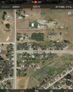
I’ll attach a screenshot of a random neighborhood in Spokane. In areas where there is no cell coverage, I can save the map for the area I’m going to and it works great because cell phone GPS works even in areas with no cell service.
The OnX app provides google-earth type aerial images with overlays and uses mobile phone GPS to show your precise location. The maps show property lines and legal property ownership information from the county auditors’ databases. Click on a piece of property and it brings up a page with the property owners information. Once you have the owners name, tracking them down is simplified.
I can drive down a street and instantly see who owns an interesting piece of property. It also shows all forms of state, federal, and other public land ownership. Best of all, it’s all on my smartphone.
I’ll attach a screenshot of a random neighborhood in Spokane. In areas where there is no cell coverage, I can save the map for the area I’m going to and it works great because cell phone GPS works even in areas with no cell service.


")