How to find ancient settlements

Justinian

Full Member
Joined
Nov 8, 2010
Messages
248
Location
Earth
I like to use Google Earth to scan farm fields for signs of old (ancient in my case) settlements. When you live on the land, you change its soil composition and structure. Even after a thousand years and annual plowing, you can't hide the fact that soil has been disturbed by something different than the surrounding farmland. In the attached image (from Google Maps) I circled an area the shows the telltale signs that something was there long before. There are also two other faint colored areas, irregular shaped, that also are worth investigating. On Saturday I will go and detect on these areas and see what I find. If anything good - I will post it here.
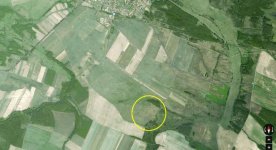
Cropped Area.jpg
 
Very cool! I use satellite imagery quite a bit to find old places to water hunt.

200 years is really old here!
 
Yes, I was actually born/raised New Hampshire so I used to dream of finding coins there were over 100 years old. Now that I live in Europe, we call then new.
 
I do the same but I prefer Bing Maps birds eye view. I search by the same principle but more in the woods. You can see the different types of trees and if they look like a natural formation or if they were planted. In New England you can find lost cart paths and railroad lines easily with a satellite view but in birds eye view sometimes you can see under the tree canopy and see things like foundations and rock walls. Gives me something to do in the winters.:grin:
 
Thanks for that cool tip. I was wondering how to use Google for searching.
 
Back
Top Bottom