
You are using an out of date browser. It may not display this or other websites correctly.
You should upgrade or use an alternative browser.
You should upgrade or use an alternative browser.
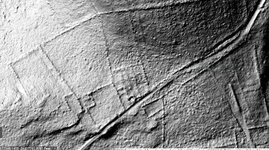
found great lidar and aerials of my new spot
- Thread starter Outdoorsman258
- Start date

HungryGhost
Forum Supporter
Those images should be a big help. Good luck with that spot!
MasonDixonMding
Elite Member
Good luck.
hoser
Forum Supporter
Now that should had oughta get right where you need to be for sure. I like it, I like it a lot. Good luck on this place
I like it, I like it a lot. Good luck on this placeOutdoorsman258
Junior Member
https://lidarandaerialarchaeology.com/north-america/is there a site you were able to get the lidar pictures from?
Cool site, I am exploring it.
Connecticut has their own Lidar site that I use... https://cteco.maps.arcgis.com/apps/webappviewer/index.html?id=c137b950f1db47c6982f7279e23a2345
Kansashunter
Elite Member
Cool images, looks to be a lot of hunting to do!
Outdoorsman258
Junior Member
I think that is the same mapping program!Connecticut has their own Lidar site that I use... https://cteco.maps.arcgis.com/apps/webappviewer/index.html?id=c137b950f1db47c6982f7279e23a2345
Try the caltopo link on the north america page www.lidarandaerialarchaeology.comI wish Ohio had better lidar viewing options.
I'll keep searching though.
Gryphon
New Member
- Joined
- Feb 24, 2024
- Messages
- 5
Dang, nothing (specific) for Michigan.Try the caltopo link on the north america page www.lidarandaerialarchaeology.com

Last edited:
markinmichigan
Forum Supporter
I noticed that as well....Welcome aboard Gryphon, cool moniker.Dang, nothing for Michigan.
Mark in Michigan
Gryphon
New Member
- Joined
- Feb 24, 2024
- Messages
- 5
Thanks Mark.I noticed that as well....Welcome aboard Gryphon, cool moniker.
Mark in Michigan
$MELTER-1
Senior Member
- Joined
- Jul 20, 2024
- Messages
- 261
Where did you get the photosCan't wait to hit this place again this year! Found it late last year and got one hunt in. Found two pot lids, an iron for clothes, and a plow point.
$MELTER-1
Senior Member
- Joined
- Jul 20, 2024
- Messages
- 261
Disregard I see
ItWhere did you get the photos